
Conor O’Neill creates beautiful handmade maps on his personal website and on his Instagram page, most of them of Dublin and environs. (I wonder if he’s ever created a map of the perambulations of Leopold Bloom from James Joyce’s Ulysses?) He has turned his talents toward recreating a remarkably detailed and accurate-seeming map from the canon, and given me permission to reproduce the images here, with the happy results you can view below. Enjoy this interview with Conor, which I hope will only be the first in a series engaging with other devotees of the canon!

The Aubrey-Maturin Review: Tell our readers a little bit about yourself.
Conor O’Neill: My name is Conor, I’m in my late 20s and I live in Dublin, Ireland. I work as an environmental consultant at an engineering firm. A good chunk of my job involves working with maps and spatial data, but it doesn’t really satisfy any creative spark so I draw maps in my spare time too.
I sailed dinghies growing up and worked for a few summers as a sailing instructor, and I’ve had a couple of other jobs working on boats since then. Currently taking a break from sailing but I plan on going back to it as soon as life allows.
TAMR: When did you first become interested in drawing maps? Do you have any formal training?
Conor: I’ve been interested in maps since I was very young, but I only started properly making my own maps during the first Covid lockdowns in 2020. For a while Ireland had a very strict lockdown restricting you to a 2km radius from your home, and while this was in effect I drew some maps of my 2km. It was a fun exercise to do while stuck at home, and it inspired me to start some other mapping projects shortly after. It’s gotten to the point where it’s very much a hobby now.
I wouldn’t necessarily call it formal training, but I did study Geography in college which included courses on Geographic Information Systems (GIS), essentially mapmaking on the computer. I use GIS software nearly every day in my job, and I occasionally incorporate it into my own personal mapping projects too. Between work and personal stuff, I’m kind of constantly working on or studying maps of some sort.
TAMR: When I was a kid, finding a book with a map in it, like Stevenson’s Treasure Island or Tolkien’s The Hobbit, seemed almost to guarantee that it would be a book I’d love. Can you relate to this?
Conor: I can definitely relate to that. A map can be a great way to start a book, it grounds the story in some sort of reality for the reader, and if it’s a good map it will add some real value to the reading experience too. I’d argue that the diagram of sails at the start of many (all? I don’t know if it appears in each entry and edition) Aubrey-Maturin books serves as a map of sorts too.
For me it was Tolkien, I first read The Lord of the Rings when I was 9 or 10 and I spent a lot of time poring over the maps of Middle Earth, and it was the same with The Hobbit. They were also some of the first maps I drew too, I would have made a lot of copies and reproductions of that classic Middle Earth map around that age. I feel like a big world map at the start is kind of a fantasy book trope at this point, but there’s a reason they keep coming and I think it’s because, when it’s a good map anyway, it can add real value to the reading experience.
TAMR: When did you first become aware of the Aubrey-Maturin novels and/or the movie?
Conor: I saw the film before I read any of the books, that was my first introduction to the series. I loved it, I was sailing myself by then and so I gave the books a try shortly after seeing it. Master and Commander was a tough read for me when I first tried it though (around 10 or 11 years old I think). I came back to the series much later and it clicked with me then. I’m so glad it did because they’re some of my favourite books now.
I still love the film as well, I think it’s perfectly crafted and by seeing it first before coming to the books, it (for better or worse) heavily influenced how I see certain characters in my mind - Jack, Stephen, and Bonden in particular.
TAMR: What were your sources and inspirations for this particular map?
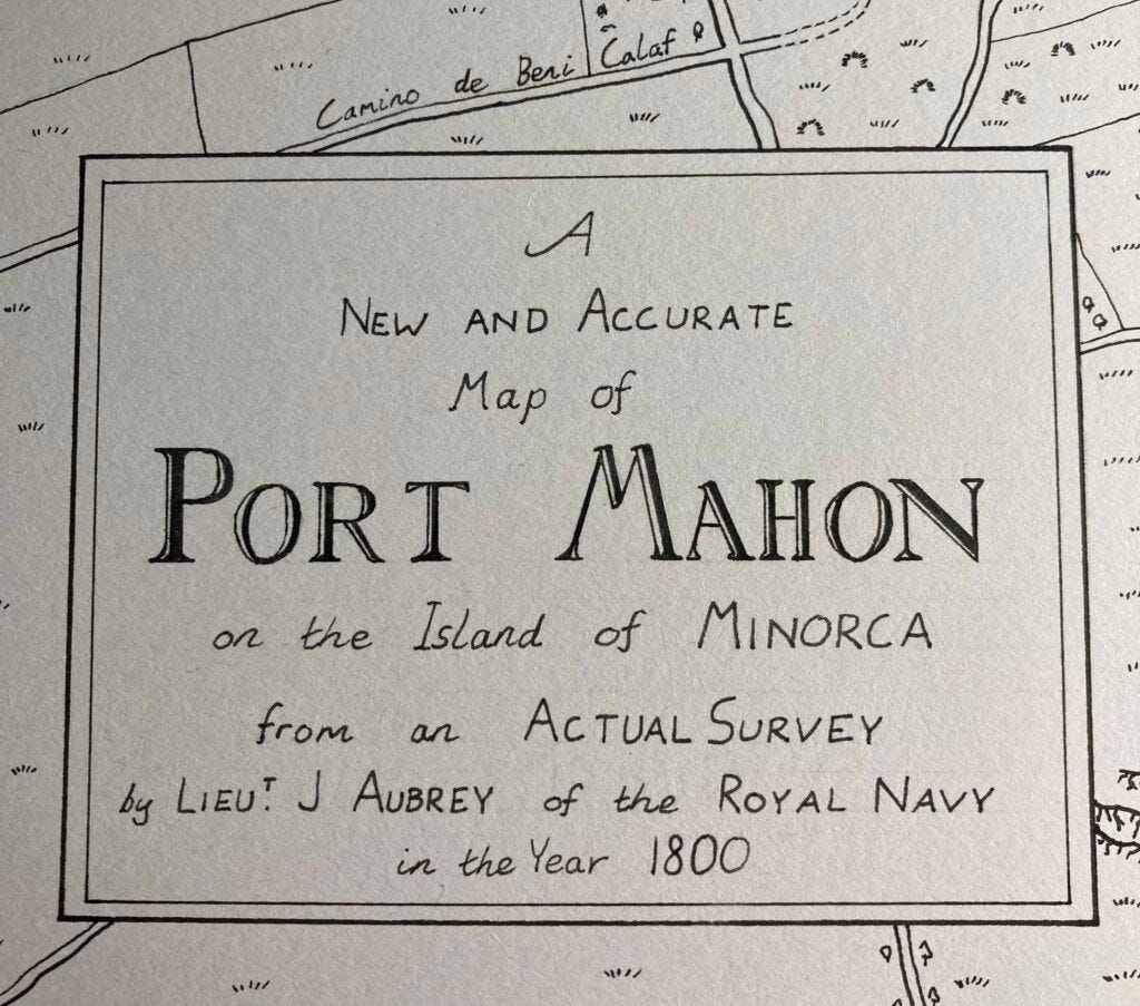
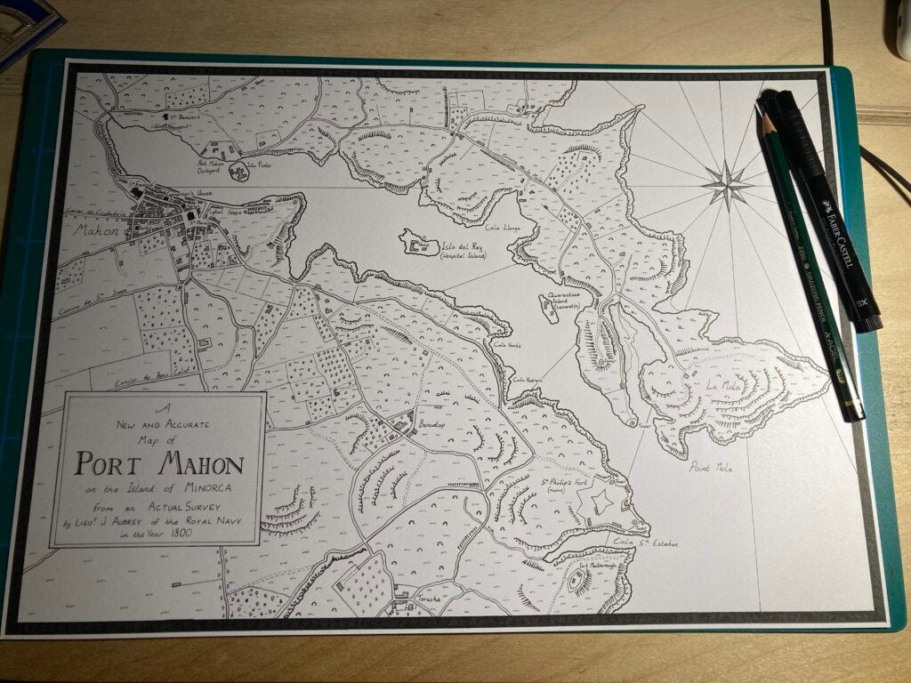
Conor: I based the map symbology on the style of the Ordnance Survey’s six-inch maps of Ireland. These were made in the mid-1800s and are such high quality and super detailed, yet really legible. I also took inspiration from some historical charts of Dublin Bay (there’s a great gallery of them here; the ones from 1800 by J. Cowan and by Captain William Bligh are particularly nice). The title text I adapted from this 1797 chart of West Falkland Island, from a Royal Navy survey. I wanted to include a nod to Jack’s love of surveying so included that there.
I wanted to make my map reasonably accurate to the time period of the books. The website OldMapsOnline was really helpful here, particularly this 1836 map, and this one from 1764. Unfortunately I couldn’t find a detailed map of Mahon from the exact time I wanted, but a combination of these two served to inspire my layout. I also did plenty of searching around on Google Maps and Google Street View for particular features which helped to pull the map together.
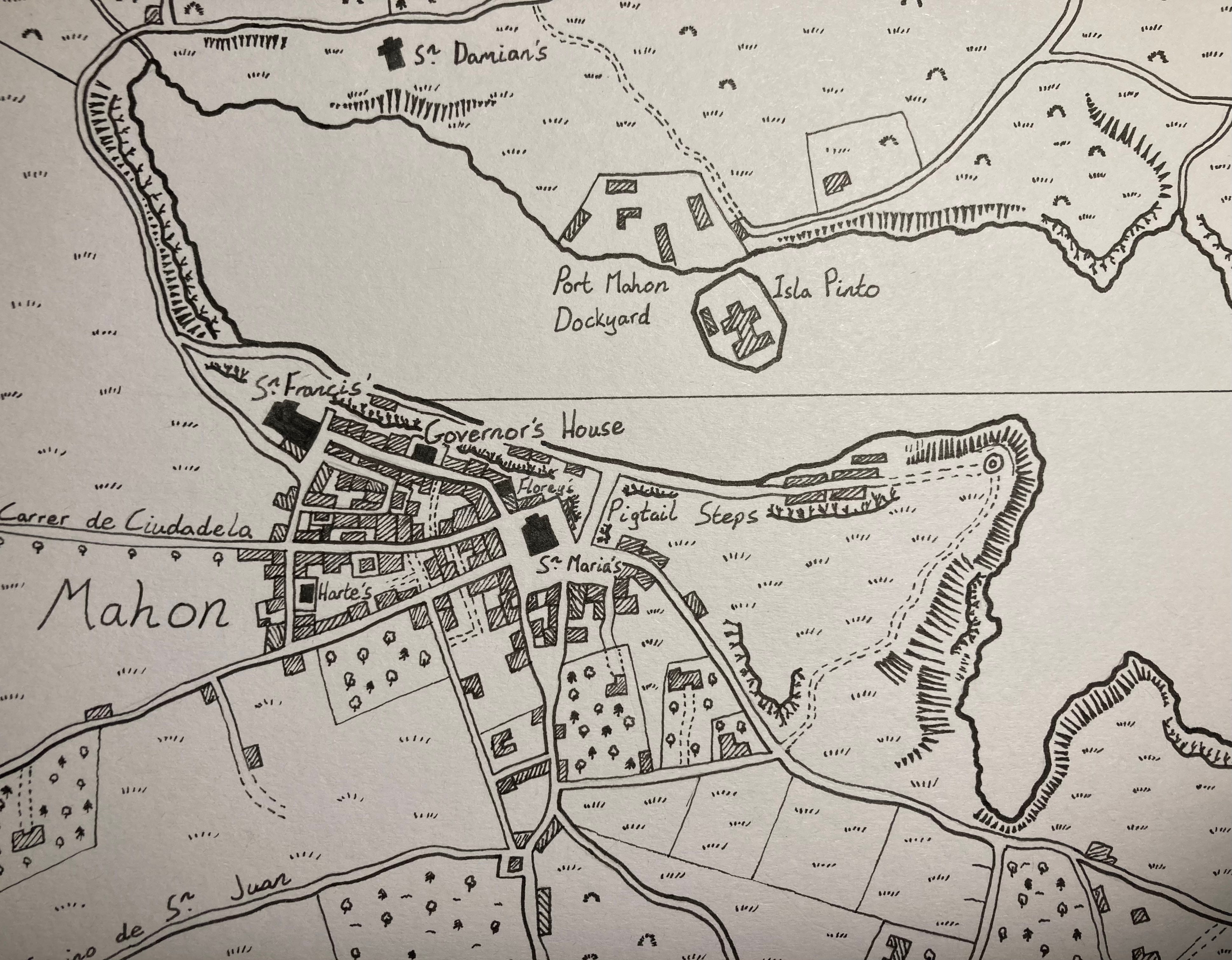
Then there’s the features from the books. I basically reread the first few chapters of Master and Commander, looking for every reference I could find to the geography of Port Mahon and specific locations. There’s also some fantastic resources online for this. This blog post from trailoftheimmortalmemory was invaluable, as were the resources listed on The Gunroom website, particularly this amazing series text search page. Any mention of “Mahon”, “Pigtail Steps”, “church”, “street”, “harbour”, etc. was a potential clue for me. This was actually a really enjoyable part of the process, each time I found a passage or line that allowed me to make a named location even a tiny bit more accurate was very satisfying.
I’d say the biggest omission is The Crown, which I didn’t include because I couldn’t find any references to where in Mahon it might be. I have to admit that since finishing the map, I regret not just including it somewhere in the town anyway, but oh well. If anyone has any ideas of where it should be located or if I missed an obvious clue, let me know!
TAMR: What tools did you use for the actual drawing? How did you make sure things were to scale? (I’ve drawn many a map for stories I’ve written and D&D adventures I’ve gone on, but I’ve never tried to draw an actual existing place.)
Conor: The map is drawn on A3 card, first with pencil and then Pitt Artist Pens, which give really nice crisp lines.
When I’m drawing a map of a real place, I tend to start with a Google Earth or Google Maps view of the extent I want to use, and place a grid over it. I then scale that grid up to my paper size and start placing some points on the page - headlands, road junctions, landmarks, etc. Then it’s a matter of filling in the blanks slowly but surely, using my grid and a ruler, and a bit of tracing from the computer screen where necessary. By taking the time to get some key points placed accurately, the gaps can be filled in between them quite nicely.
TAMR: Will you draw more canon-inspired maps in the future?
Conor: Yes I’d certainly like to, and I have a couple of ideas at the moment but nothing I’ve committed to yet. Mahon seemed like the perfect place to start for a few reasons. The fact the story begins there and that so much takes place there really helps. I also find the harbour itself is such a great natural shape and just lends itself really well to being put on a page, its shape is just visually interesting I think. Then, and I’m making an assumption here, I feel that Mahon is not somewhere most people would be familiar with. London is a setting in many of the books but not one that really interests me from a mapping point of view, partially because I already have a mental picture of the geography of London in my head, and I’d guess a lot of other people do too.
So to make a long answer shorter, yes I would definitely like to do some more A-M maps, but I need to find the right place first. In the meantime I’m working on plenty of other non-Aubrey-Maturin maps which are keeping me busy.

Capitol! Capitol! but just one thing, if Midshipmen Aubrey were to have conducted this survey surely and perhaps most importantly it would include a magnetic compass rose with true north as well soundings and perhaps a few bathymetric isobaths, and the location / height of promitory peaks and church steeples and such as these were (and in some cases still are) used for very precise navigation and for creating the map in the first place :)
Such additions would make it a prime piece indeed!
Though i dare say yours has more of the middle earth flare and zest so i congratulate you there!
Just as this Admiralty chart of 1887 has: https://commons.wikimedia.org/wiki/File:Admiralty_Chart_No_148_Minorca_Port_Mahon,_Published_1897.jpg
Wonderful!